Research

Home page category

Framing Water Sustainability in an Environmental Decision Support System

Author

Dave D. White
Co-director, Decision Center for a Desert City
Associate Professor, School of Community Resources and Development
Senior Sustainability Scientist, Global Institute of Sustainability
Arizona State University

Publication

Society and Natural Resources published online on June 14, 2013.

Abstract

This case study applies the theoretical concepts of frame and framing processes to identify and describe the diagnostic and prognostic frames for water sustainability expressed through an environmental decision support system. The research examines the development of WaterSim, a computer simulation model of water supply and demand in central Arizona. Qualitative data were generated through semistructured individual and group interviews, participant observations, and document analysis. The analysis identified a diagnostic frame defining the water sustainability problem as uncertain and long-term water supply shortage caused by prolonged drought, climate change impacts, and population growth. The prognostic frame for water sustainability defined the solutions to be urban residential water demand management, retirement of agricultural lands, and conversion of agricultural water to municipal uses to achieve safe yield of groundwater. The results of the study are discussed in terms of implications for decision support systems (DSS) design.

Limits to Flood Forecasting in the Colorado Front Range

Title

Limits to Flood Forecasting in the Colorado Front Range for Two Summer Convection Periods using Radar Nowcasting and a Distributed Hydrologic Model

Authors

Hernan A. Moreno, (1),(2)
Enrique R. Vivoni, (1),(3)
David J. Gochis, (4)

Publication

Journal of Hydrometeorology 2013 ; e-View
doi: http://dx.doi.org/10.1175/JHM-D-12-0129.1

Abstract

Figure 10. Spatial distribution of total (a) rainfall and (b) runoff at LTHOM during Storm 2004, 2 using QPE forcing; mean ensemble difference of precipitation for (c) 60-min and (e) 180-min 3 lead times; and mean ensemble differences of runoff for (d) 60-min and (f) 180-min lead times.
Figure 10. Spatial distribution of total (a) rainfall and (b) runoff at LTHOM during Storm 2004,
2 using QPE forcing; mean ensemble difference of precipitation for (c) 60-min and (e) 180-min
3 lead times; and mean ensemble differences of runoff for (d) 60-min and (f) 180-min lead times.
Flood forecasting in mountain basins remains a challenge given the difficulty in accurately predicting rainfall and in representing hydrologic processes in complex terrain. This study identifies flood predictability patterns in mountain areas using quantitative precipitation forecasts for two summer events from radar nowcasting and a distributed hydrologic model. We focus on eleven mountain watersheds in the Colorado Front Range (CFR) for two warm-season convective periods in 2004 and 2006. The effects of rainfall distribution, forecast lead time and basin area on flood forecasting skill are quantified by means of regional verification of precipitation fields and analyses of the integrated and distributed basin responses. We postulate that rainfall and watershed characteristics are responsible for patterns that determine flood predictability at different catchment scales. Coupled simulations reveal that the largest decrease in precipitation forecast skill occurs between 15 and 45-min lead times that coincide with rapid development and movements of convective systems. Consistent with this, flood forecasting skill decreases with nowcasting lead time, but the functional relation depends on the interactions between watershed properties and rainfall characteristics. Across the majority of the basins, flood forecasting skill is reduced noticeably for nowcasting lead times greater than 30-min. We identified that intermediate basin areas (~2 to 20 km2) exhibit the largest flood forecast errors with the largest differences across nowcasting ensemble members. The typical size of summer convective storms is found to coincide well with these maximum errors, while basin properties dictate the shape of the scale dependency of flood predictability for different lead times.

Read more here.

(1) School of Sustainable Engineering and the Built Environment, Arizona State University, Tempe, AZ 85287
(2) Decision Center for a Desert City, Global Institute of Sustainability, Arizona State University, Tempe, AZ 85287
(3) School of Earth and Space Exploration, Arizona State University, Tempe, AZ 85287
(4) National Center for Atmospheric Research, Boulder, CO

Historical threshold temperatures for Phoenix (urban) and Gila Bend (desert), central Arizona, USA

Climate Research, Vol 55, No. 3
January 10, 2013

Authors

D. Ruddell [1], D. Hoffman [2], O. Ahmad [3], A. Brazel [4]

Abstract

Several critically important temperature thresholds are experienced in the climate of the desert southwest USA and in central Arizona. These thresholds present significant and increasing challenges to social systems. Utilizing daily surface air temperature records from Phoenix and Gila Bend regional weather stations from 1900−2007, we examined 3 temperature thresholds: (1) frost days (minimum temperature < 0°C); (2) misery days (maximum temperature ≥43.3°C); and (3) local characteristics of heat waves. We investigated historic climate patterns in addition to considering the human implications associated with these changes. Analyses also integrated multidecadal modes of the El Niño−Southern Oscillation (ENSO) and the Pacific Decadal Oscillation (PDO). Key findings of this study were: (1) uneven warming trends among temperature thresholds between the Phoenix (pronounced warming) and Gila Bend (modest warming) weather stations; (2) disjointed associations between ENSO and PDO with frost and misery days, signaling anthropogenic interference between temperature thresholds and historic atmospheric processes; (3) variable effects of ENSO and PDO modulations on annual frost and misery days; (4) evidence of urbanization suppressing local effects of global climate systems (i.e. ENSO, PDO); and (5) potentially significant and widespread adverse impacts on many local environmental, economic, and social systems as a result of changes in threshold temperatures.

Key Words

Temperature thresholds, Urban heat island, Phoenix, Gila Bend, Coupled natural-human systems

[1] Spatial Sciences Institute, University of Southern California, Los Angeles, California 90089-0374, USA
[2] School of Natural Resources and Environment, University of Michigan, Ann Arbor, Michigan 48109-1041, USA

[3] School of Sustainability, Arizona State University, Tempe, Arizona 85287-5502, USA

[4] School of Geographical Sciences and Urban Planning, Arizona State University, Tempe, Arizona 85287-5302, USA

A comprehensive sustainability appraisal of water governance in Phoenix, AZ

Authors: Kelli L. Larson (a,b), Arnim Wiek (a), Lauren Withycombe Keeler (a)

Journal of Environmental Management

Volume 116, 15 February 2013, Pages 58–71

Abstract

Saguaro Lake FourPeaks
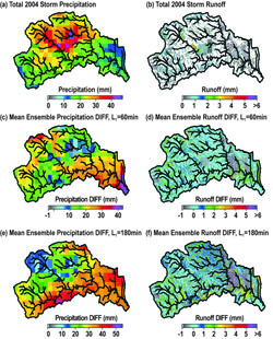
In Phoenix, Arizona and other metropolitan areas, water governance challenges include variable climate conditions, growing demands, and continued groundwater overdraft. Based on an actor-oriented examination of who does what with water and why, along with how people interact with hydro-ecological systems and man-made infrastructure, we present a sustainability appraisal of water governance for the Phoenix region.

Broadly applicable to other areas, our systems approach to sustainable water governance overcomes prevailing limitations to research and management by: employing a comprehensive and integrative perspective on water systems; highlighting the activities, intentions, and rules that govern various actors, along with the values and goals driving decisions; and, establishing a holistic set of principles for social–ecological system integrity and interconnectivity, resource efficiency and maintenance, livelihood sufficiency and opportunity, civility and democratic governance, intra- and inter-generational equity, and finally, precaution and adaptive capacity.

This study also contributes to reforming and innovating governance regimes by illuminating how these principles are being met, or not, in the study area. What is most needed in metropolitan Phoenix is enhanced attention to ecosystem functions and resource maintenance as well as social equity and public engagement in water governance.

Overall, key recommendations entail: addressing interconnections across hydrologic units and sub-systems (e.g., land and water), increasing decentralized initiatives for multiple purposes (e.g., ecological and societal benefits of green infrastructure), incorporating justice goals into decisions (e.g., fair allocations and involvement), and building capacity through collaborations and social learning with diverse interests (e.g., scientists, policymakers, and the broader public).

Continue to the full text of the article at Science Direct.

(a) School of Sustainability, Arizona State University, Mail Code 5502 Tempe, AZ 85287-5502, USA
(b) School of Geographical Sciences and Urban Planning, Arizona State University, Mail Code 5302 Tempe, AZ 85287-5302, USA

Survey Results on Water Resource and Land Use Planning in the Phoenix Metropolitan Area

In the report, Views and Activities among Municipal Water Managers and Land Planners: Stressors and Strategies for Resource Management in Metropolitan Phoenix, AZ, DCDC Co-PI Kelli Larson presents 2010 survey results aimed at understanding water resource and land use planning activities across municipalities in the greater Phoenix region.

Overview

sunlight shining through treesSince land use and land cover (e.g., vegetation) affect water demand, and since water use and conservation affect the condition and management of land use and land cover, a primary objective of this research is to explore the potential for integrated planning across sectors. With special attention to land-water connections under climate variability and urbanization, we focus on planning strategies within and across sectors.

Here, we present the results from two sets of survey questions. First, we explore how professional views about water resource stressors and management strategies converge and diverge among water resource managers (WRMs) and land use planners (LUPs) (i.e., to what extent do these two groups hold similar or different perspectives from one another). Second, we examine the degree to which water managers and land planners are engaging in integrated planning by asking them the degree to which they consider both issues in their decision making (i.e., water issues in land planning and land issues in water management) and the extent to which they are involved in planning activities in the other sector (i.e., WRMs in land planning and LUPs in water management).

Continue reading and download Views and Activities among Municipal Water Managers and Land Planners: Stressors and Strategies for Resource Management in Metropolitan Phoenix, AZ.

Kelli larsonKelli Larson, Ph.D. is a DCDC Co-PI and an Associate Professor in the Schools of Geographical Sciences and Urban Planning and Sustainability at Arizona State University and a Senior Sustainability Scientist at the Global Institute of Sustainability. Dr. Larson’s areas of interest include human-environment interactions, water resource governance, and social aspects of sustainability.

Getting Outside the Water Box: The Need for New Approaches to Water Planning and Policy

Patricia GoberDCDC founding director, Patricia Gober, writes in the January 15, 2013 editorial for the journal Water Resources Management, that North American water systems are inadequately prepared to deal with an uncertain future climate and other uncertainties relevant to long-term sustainability.

The water resources community has been slow to embrace new paradigms for long-term water planning and policy. Too much attention has been focused on reducing, clarifying, and representing climatic uncertainty and too little attention has been directed to building capacity to accommodate uncertainty and change.

Given the limited ability to forecast the future climate, emphasis must shift to the human actors and social dynamics of water systems, including planning processes, work practices, operational rules, public attitudes, and stakeholder engagement.

Continue reading the editorial at Water Resources Management.

New DCDC Publication

DCDC Publication

Tradeoffs Between Water Conservation and Temperature Amelioration in Phoenix and Portland: Implications for Urban Sustainability

Authors

Patricia Gober [1, 2]
Ariane Middel [3]
Anthony Brazel [1]
Soe Myint [1]
Heejun Chang [4]
Jiunn-Der Duh [4]
Lily House-Peters [4]

Abstract

This study addresses a classic sustainability challenge—the tradeoff between water conservation and temperature amelioration in rapidly growing cities, using Phoenix, Arizona and Portland, Oregon as case studies. An urban energy balance model— LUMPS (Local-Scale Urban Meteorological Parameterization Scheme)—is used to represent the tradeoff between outdoor water use and nighttime cooling during hot, dry summer months. Tradeoffs were characterized under three scenarios of land use change and three climate-change assumptions. Decreasing vegetation density reduced outdoor water use but sacrificed nighttime cooling. Increasing vegetated surfaces accelerated nighttime cooling, but increased outdoor water use by ~20%. Replacing impervious surfaces with buildings achieved similar improvements in nighttime cooling with minimal increases in outdoor water use; it was the most water-efficient cooling strategy. The fact that nighttime cooling rates and outdoor water use were more sensitive to land use scenarios than climate-change simulations suggested that cities can adapt to a warmer climate by manipulating land use.

Download publication. You may or may not have access through your institution.

[1] School of Geographical Sciences and Urban Planning, Arizona State University
[2] Johnson-Shoyama Graduate School of Public Policy, University of Saskatchewan, Saskatoon, Canada
[3] Decision Center for a Desert City, Arizona State University
[4] Department of Geography, Portland State University

DCDC-Intel-CH2M Hill Collaboration

By Skip Derra at ASU News

CH2M HILL’s WaterMatch, a grassroots, goodwill initiative that promotes the reuse of municipal effluent for industrial and agricultural use, is expanding through collaborations with companies and universities around the world. Arizona State University and Intel are among the targets for this expansion in the U.S.

CH2M HILL, a program management, construction management and design firm located in Denver, developed WaterMatch as a free website that uses social networking and geospatial mapping to connect water generators with water users. “We are expanding WaterMatch and the grassroots water reuse revolution to promote progress through partnerships and projects on the ground,” said Jan Dell, vice president at CH2M HILL. “We invite companies, municipalities and universities to join us in this effort.”

CH2M HILL launched WaterMatch in 2011. Recognizing the importance of water reuse and the low rates of implementation around the world, corporations and universities are partnering with WaterMatch to promote reuse and sustainable water management through a variety of actions. WaterMatch has more than 21,000 potential water reuse sources and is growing daily.

ASU and Intel are working with local municipalities in Arizona and the U.S. Southwest to populate the WaterMatch map and associated wastewater treatment plant profiles. They also are conducting research into the uses and benefits of WaterMatch.

“Sustainable water management is a key focus at Intel,” said Gary Niekerk, director of Corporate Citizenship at Intel. “We created the external collaboration with CH2M HILL‘s WaterMatch, ASU’s Global Institute of Sustainability and ASU’s Decision Center for a Desert City to increase water sustainability in our local community.” Niekerk added that Intel believes that technology can play an important role in addressing the world’s sustainability challenges.

The university program will leverage what is learned from successful pilot projects at Arizona State University and the University of California-San Diego.

“Our students are eager to engage on the critical issue of water sustainability in Arizona and work on a grassroots project,” said John Sabo, director of Research Development at ASU’s Global Institute of Sustainability. “It’s great to see the program our students helped to pilot expand globally.”

Also helping to populate the map and grow the user base are SGS, a global inspection, testing, verification and certification company in Poland; British Water in the United Kingdom; and ConocoPhillips, working in Indonesia.

To tap into the energy and creativity of students, and offer them real-world learning experiences that support local community and economic development, WaterMatch is collaborating on a global WaterMatch Makers university program with Net Impact, a global nonprofit that supports a new generation of leaders who work for a more sustainable world.

Has Surface Water Quality Improved Since the Clean Water Act?

Authors

V. Kerry Smith and Carlos Valcarcel Wolloh
Department of Economics
W. P. Carey School of Business
Arizona State University

June 2012
JEL No. Q50,Q53

Abstract

On the fortieth anniversary of the Clean Water Act this paper reports the first quantitative assessment of the aggregate trends in water quality in the U.S. using a single standard over the years 1975 to 2011. The analysis suggests that fresh water lakes for the nation as a whole are about at the same quality levels as they were in 1975. In short, viewed in the aggregate, nothing has changed. An assessment of the factors influencing the aggregates also suggests that water quality appears to be affected by the business cycle. This result calls into question the simple descriptions of the change in environmental quality with economic growth that are associated with the Environmental Kuznets Curve. Download the paper at the National Bureau of Economic Research.

DCDC Research Article Chosen for Collection on Desertification and Drought

June 17th marked the United Nations World Day to Combat Desertification and Drought.

In 1994, the United Nations General Assembly declared the 17th of June the World Day to Combat Desertification and Drought to promote public awareness of the issue, and the implementation of the United Nations Convention to Combat Desertification (UNCCD) in those countries experiencing serious drought and/or desertification, with particular emphasis on Africa.

Working with editors and authors, Routledge Taylor & Francis has compiled a list of over 80 leading articles from 50 academic journals to support this United Nations World Day.

One of the articles chosen for the collection on drought is a 2010 paper published by DCDC researchers and colleagues from the City of Phoenix Water Service Department: Pat Gober, Anthony J. Brazel, Ray Quay, Soe Myint, Susanne Grossman-Clarke, Adam Miller, and Steve Rossi. Using watered landscapes to manipulate urban heat island effects: How much water will it take to cool Phoenix? Journal of the American Planning Association 76(1):109-121.

The articles are free to access for a limited time and cover a wide range of topics and subject areas. View the article collection today.